The Collin County Outer Loop is a 55-mile planned multi-modal transportation facility that will ultimately go
from the Denton/Collin County Line, through cities including Celina, Weston, Anna, Melissa, Farmersville, Josephine
and Royse City, to the Rockwall/Collin County Line. The facility will include a freeway with a wide area in the
center reserved as a future transit corridor.
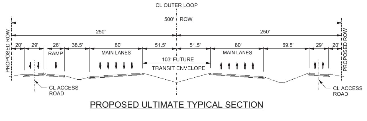
Since 2000, the County has been in the process of planning for the facility starting with a corridor study and
leading up to the identification of a preferred alignment. A diagram of the 500-foot wide right of way is shown below
to illustrate how the facility is perceived to be utilized.
An overview of the alignment can be seen in the County's
 interactive map for more detail.
The freeway is being built in a phased approach. The construction of the service roads will be developed ahead of the
freeway main lanes and the center will be reserved for the transit corridor.
Status
The Outer Loop is being developed in five segments, as can be seen on the overview map. Below is the most recent
activity for each of the segments.
Segment 1: U.S. 75 to S.H. 121 (Between Anna and Melissa)
The County completed the two-lane roadway, which will function as the future westbound service road of the freeway,
from US 75 to SH 121. The County is currently working on the schematic design.
Environmental Documents
Segment 2: FM 6 (Between Nevada and Josephine) to Rockwall County line (E. of Royse City)
A technically preferred alignment for Segment 2 was approved in 2009. The County is currently working on a project
refining the previous alignment to develop the schematic design and local environmental document. Engaging the
public, city leaders, and other stakeholders is an important part of this project. Learn more and sign up to
receive notices by visiting the project website
here.
Segment 3: Denton/Collin County Line (in Celina) to U.S. 75 (Between Anna and Melissa)
Construction
The County completed the 2-lane roadway from Dallas Pkwy to FM 2478 (Custer Rd.).
Construction of a 2-lane roadway from FM 2478 (Custer Rd.) to US 75 is tentatively scheduled to be completed by late
2025.
Design
Design is on going for the second set of service roads from Denton/Collin County line to Choate Pkwy.
Environmental Documents
Schematic
The County has completed a schematic for the future Outer Loop freeway from the Denton/Collin County Line to US 75
as well as concept designs for the future Outer Loop at the interchanges with US 75, Preston Rd./SH 289 and the
Dallas North Tollway. Those documents can be found in the links below.
Schematic files from Denton/Collin County Line to FM 2478 (Custer Rd.):
Schematic files from FM 2478 (Custer Rd.) to US 75:
Concept plan for US 75/CCOL Interchange:
The concept plans for the interchanges at Preston Rd. and the DNT are incorporated in the schematics.
Segment 4: US 380 (in Farmersville) to FM 6 (Josephine)
A technically preferred alignment for Segment 4 was approved in 2010. The County is currently working on a project
refining the previous alignment to develop the schematic design and local environmental document. Engaging the
public, city leaders, and other stakeholders is an important part of this project. Learn more and sign up to
receive notices by visiting the project website
here.
Segment 5: S.H. 121 (in between Anna and Melissa) to U.S. 380 in Farmersville
The
technically preferred alignment was approved in 2006. The County is currently
working on a project refining the previous alignment. Engaging the public, city leaders, and other stakeholders
is an important part of this project. Learn more and sign up to receive notices by visiting the project website
here.
Upcoming Event: Virtual Public Meeting (Not a Live Event)
When: Thursday, November 13, 2025 - December 15, 2025
Where:
Project Website
Location:
Virtual Public Meeting Notice
(PDF)
Historical Documents and Information
For Historical Corridor, Alignment and Public Information, please contact the Collin County Engineering department at
(972) 548-3727 or
engineering@collincountytx.gov